
Mendoza Roads: The Day We Explored the Province's Routes

There comes a point in life when the road journey unfolds in a personal and spontaneous way. Different motives may lead us to visit a place, and this experience has a unique and untransferable impact on us. It often happens on the roads of Mendoza. I'm not sure if it's the soil conducive to wine, the mountains, the air, or the combination of these conditions, but there's a different and very distinctive energy that resonates, touching each person in a different way. That's why we decided to share our experience of the various roads and routes that are part of this oasis called Mendoza. We'll also provide some recommendations to fully enjoy the journey.
Road to Villavicencio
The first road we encountered was Provincial Route 52, which connects the capital with the Villavicencio Natural Reserve, where the traditional hotel of the same name is located. From there, we headed to Uspallata, on a picturesque gravel road that is easily passable with a regular car. As we ascend the 3000-meter-high mountain, we can enjoy the stunning views and often come across guanacos and foxes that are part of the local fauna.
This gravel road is picturesque and in decent condition, suitable for normal cars.
Midway through the journey, we can visit the now-called "Ghost City of Paramillos," where we can see the Jesuit cross and the mines, considered the first mining exploitation in Argentina and one of the oldest and most important in the Viceroyalty of the Río de La Plata until the late 20th century.
Further along the journey, we encounter a 80-meter-deep ravine, which is not signposted, so be attentive. There's a concrete balcony with a railing to peer over the precipice.
As we approach Uspallata, the road is very beautiful, framed by centuries-old Araucaria trees that turn yellow in the autumn.
Road to the Christ the Redeemer Monument
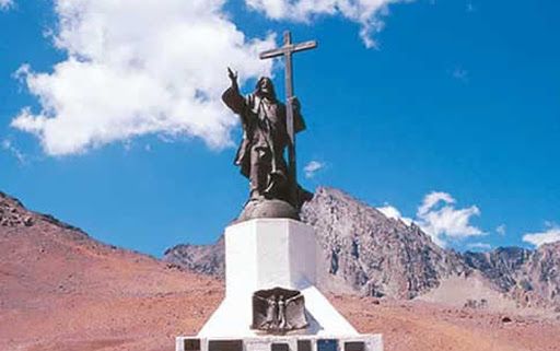
Next, we ascend to the famous Christ the Redeemer, located 208 kilometers from the city of Mendoza and at an altitude of 4000 meters above sea level, precisely on the exact border between Argentina and Chile. The monument was a conclusion to a long chapter of confrontations over determining the bilateral border, symbolizing peace and international friendship between the two nations.
The road is a winding and very narrow gravel road, so caution is necessary as sometimes only one vehicle can fit, and in those cases, the uphill vehicle has the right of way. It is open to all types of vehicles.
Once in Las Cuevas, where the monument is located, we can stop to visit Puente del Inca, Aconcagua Provincial Park, and its Horcones Lagoon.
The most recommended time to visit this place is in the summer, especially in March. During winter, passage becomes almost impossible due to the snow that covers almost all the ground. Even if you visit during the recommended season, bear in mind that the wind is strong, and temperatures are low, so I recommend bringing warm clothing.
Road to Laguna del Diamante
We head to the Uco Valley, specifically to the San Carlos department, via the new stretch of National Route 40 that connects to Provincial Route 98. The road is special for those who enjoy nature and photography due to its scenic views. Be prepared for a patient drive along the 40km of winding gravel road from Puesto Alvarado to Laguna del Diamante.
We reach the lagoon, lying at the foot of the Maipo volcano.